Introduction
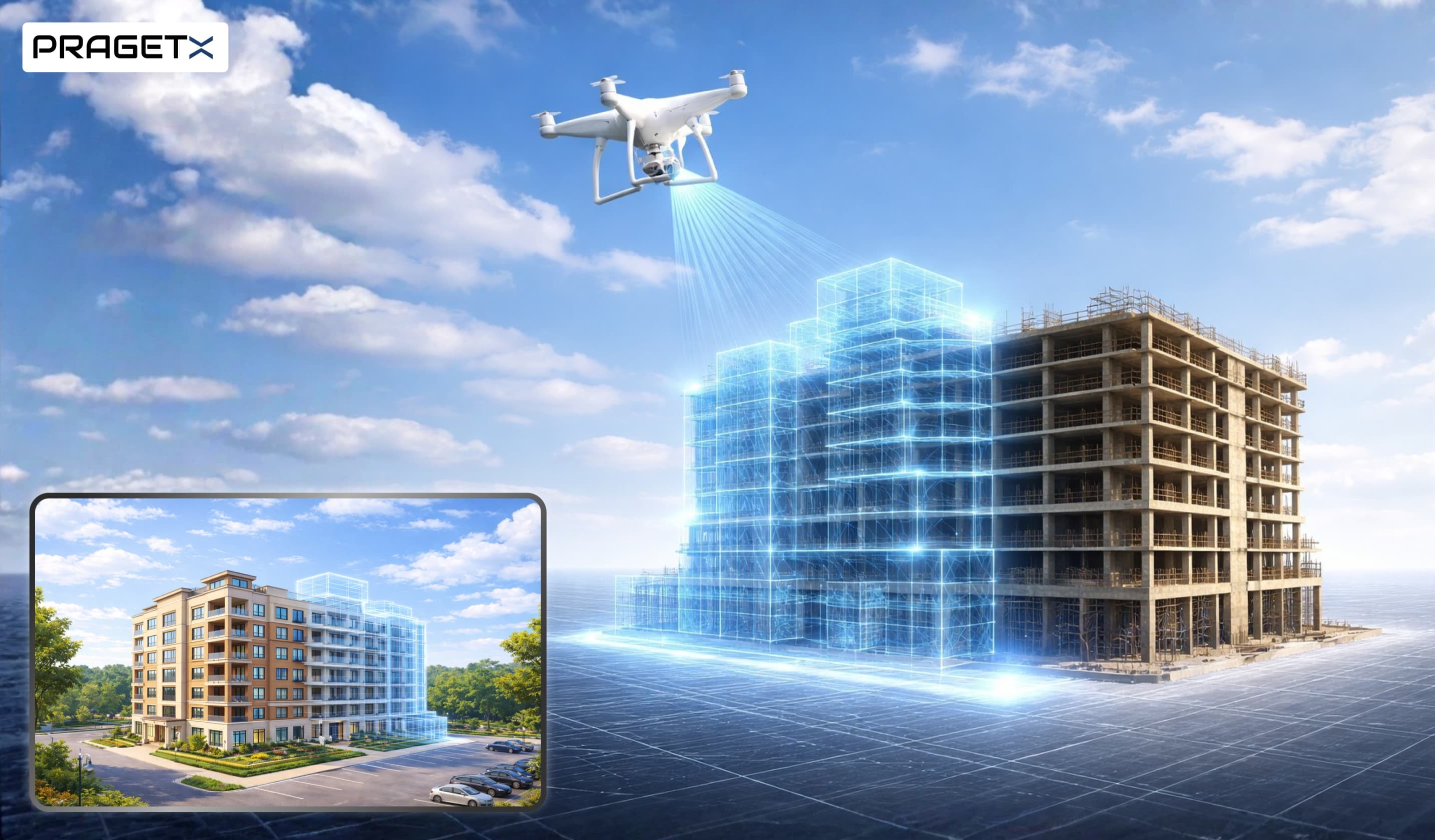
The construction industry is undergoing a rapid digital shift, driven by the need for cost efficiency, faster project delivery, risk reduction, and improved accuracy. As we move through 2025, three technologies have emerged as the most transformative: Drones, Augmented Reality (AR), and Building Information Modeling (BIM).
Individually, each technology delivers significant value. Together, they form a powerful ecosystem that accelerates timelines, enhances collaboration, and ensures flawless project execution.
From real-time aerial insights to immersive field visualization and smarter planning workflows, this tech trio is reshaping how infrastructure, real estate, and urban megaprojects are designed, built, and managed.
1. Drones: Aerial Intelligence for Faster, Safer Construction
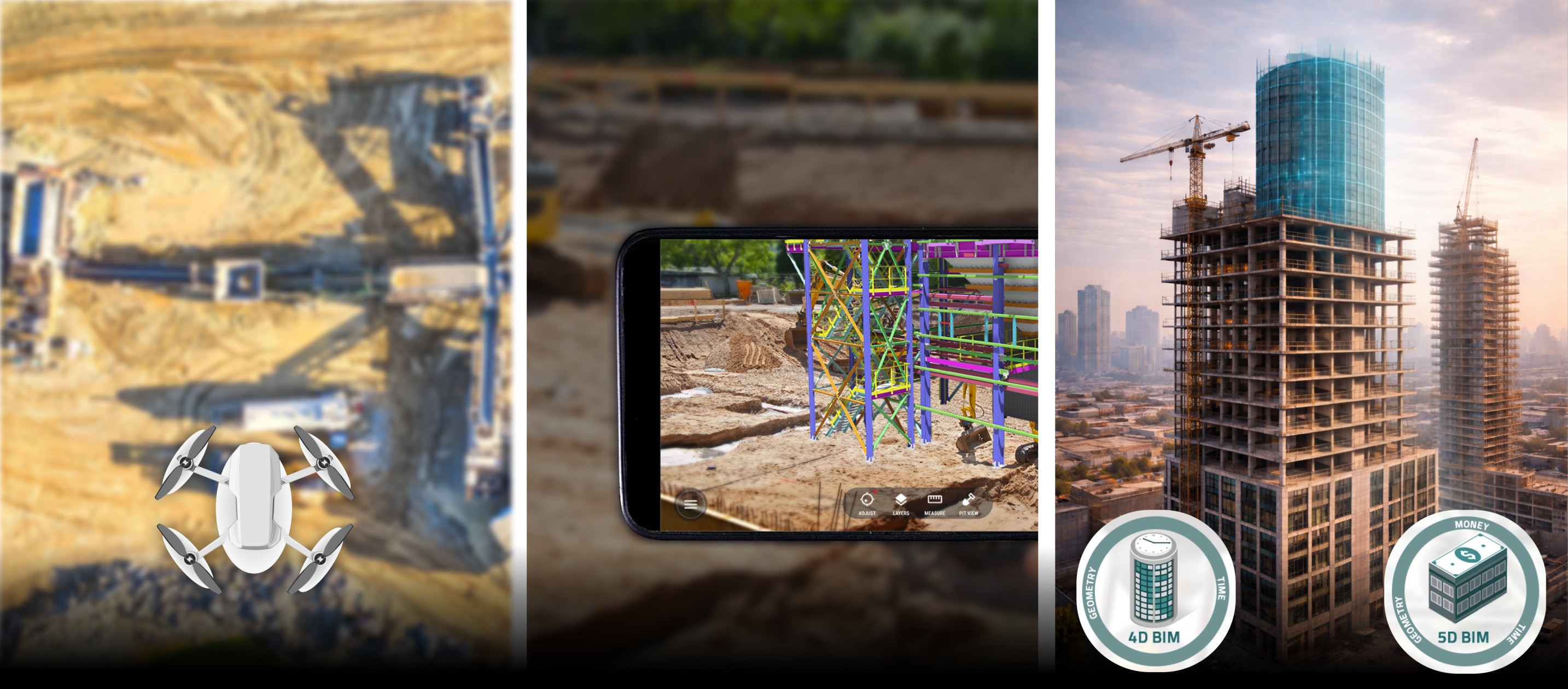
Drones have evolved from aerial photography tools to advanced surveying, monitoring, and inspection systems. Equipped with LiDAR, thermal cameras, and high-definition imaging, drones now provide unparalleled site insights that once required days of manual labor.
a. Faster and More Accurate Land Surveying
Traditional surveys rely on ground teams that take weeks to map large or difficult terrains. Drone-based LiDAR mapping drastically reduces this time while enhancing accuracy.
Live Example:
Mumbai Coastal Road Project (India)
Drone surveys helped map the coastline and construction progress with millimeter-level accuracy. This reduced surveying time by over 60% and improved environmental impact monitoring during excavation and tunneling works.
b. Real-Time Progress Tracking
Drones automatically capture daily or weekly site progress and integrate with project management tools. This creates time-lapse visuals, digital twins, and progress analytics.
Live Example:
China’s Xiong'an Smart City Project
Drones monitor the construction of highways, water channels, and public facilities, feeding real-time updates into a centralized digital command center. This enabled planners to identify delays instantly and optimize workflows, saving months in project timelines.
c. Structural & Safety Inspections
Drones equipped with thermal imaging detect cracks, water leaks, and structural defects without requiring human workers to climb dangerous areas.
Live Example:
Dubai Metro Expansion
Thermal drones inspected elevated tracks and tunnel edges in record time, reducing downtime by 40% and eliminating risk for maintenance teams.
2. Augmented Reality (AR): Real-Time Visualization on the Field
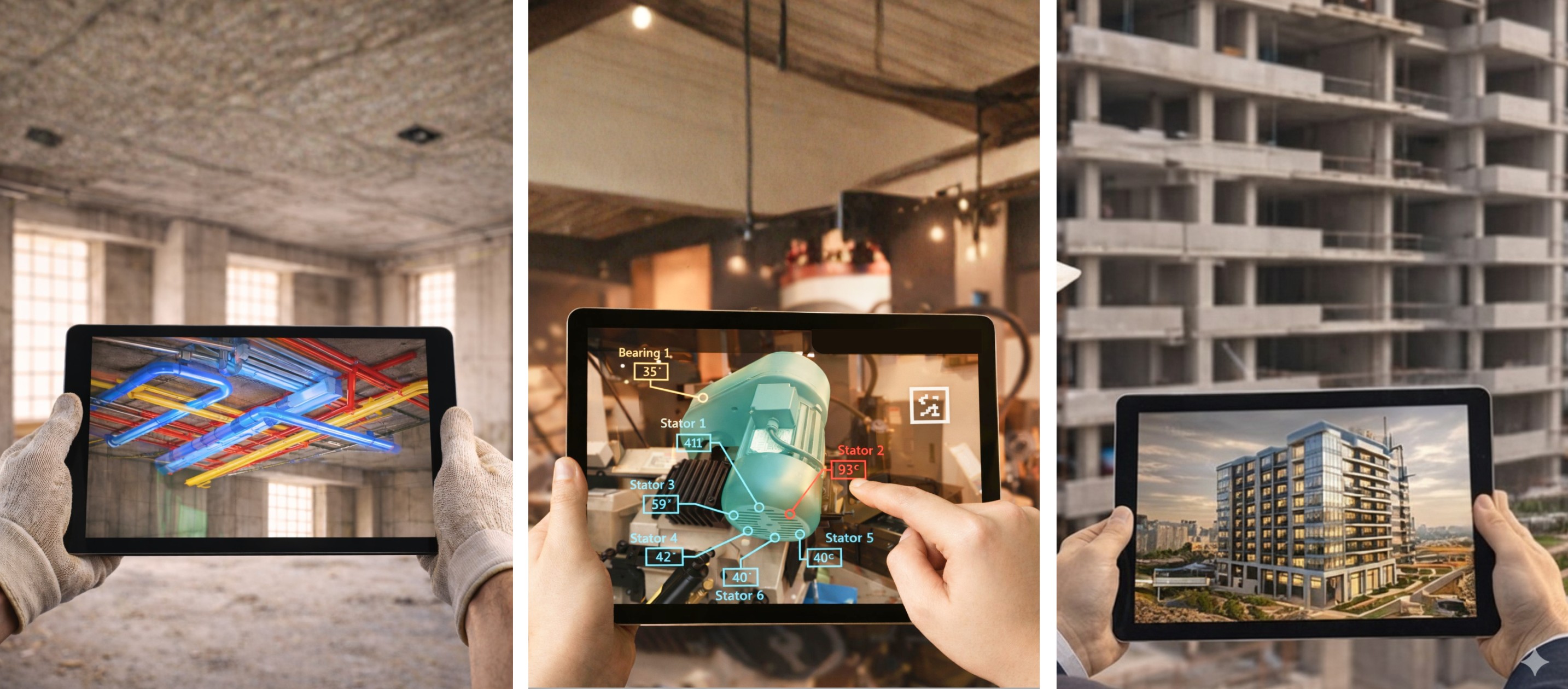
Augmented Reality overlays digital building models, instructions, and data onto the physical job site through mobile devices, AR glasses, or tablets. In 2025, AR will have become a core tool for eliminating rework, improving collaboration, and enhancing worker productivity.
a. AR for Installation Accuracy
Workers can visualize mechanical, electrical, and plumbing (MEP) layouts on-site before installation. This prevents costly mistakes caused by misalignment.
Live Example:
HoloLens 2 used by Skanska (USA)
Skanska used AR to project MEP models onto the jobsite. This reduced MEP installation issues by 75%, saving thousands of dollars and cutting coordination time in half.
b. AR for On-site Training
AR allows new workers to learn installation steps, safety procedures, and equipment assembly with guided digital overlays.
Live Example:
Kiewit Construction uses AR training
The company reported a 30% reduction in training time for equipment operators using AR simulations instead of classroom-based training.
c. AR for Client Demonstrations & Approvals
Developers can walk clients through the construction site while showing finished interiors, façade changes, or structural modifications through AR. Approvals become faster and more accurate.
Live Example:
Singapore Housing Development Board (HDB)
AR walkthroughs helped clients visualize flats under construction. This improved transparency and reduced redesign requests by 40%.
3. Building Information Modeling (BIM): The Digital Backbone of Construction
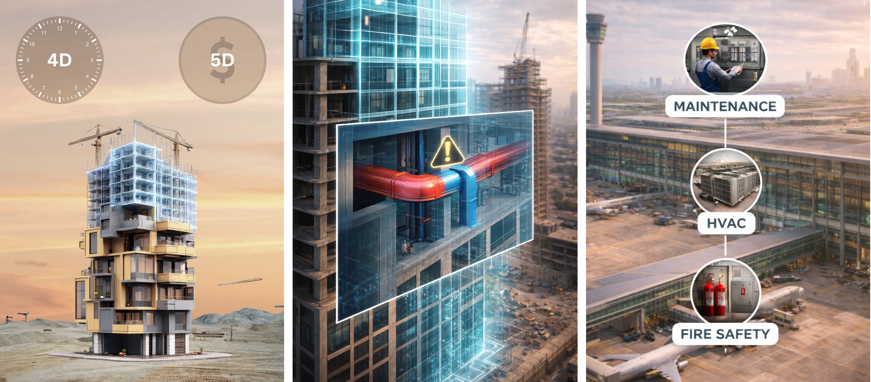
BIM is the foundation of digital construction. It enables 3D modeling with embedded data about structure, materials, MEP systems, scheduling, costing, and maintenance.
In 2025, BIM has matured into a central ecosystem that connects drones, AR, IoT devices, and project management platforms.
a. 4D and 5D BIM for Scheduling & Cost Optimization
4D BIM adds time, helping planners simulate construction sequences.
5D BIM adds cost, giving real-time budget updates as models evolve.
Live Example:
HS2 High-Speed Rail (UK)
The project uses 5D BIM to coordinate thousands of components, contractors, and construction sequences. This resulted in cost savings of over £1 billion through real-time clash detection and resource optimization.
b. BIM for Clash Detection and Rework Reduction
BIM platforms such as Revit, Navisworks, and Tekla detect conflicts between structural and MEP components before construction begins.
Live Example:
Doha Metro Project (Qatar)
Using BIM clash detection, the team resolved over 3,000 issues before construction, reducing rework by 70% and speeding up station completion.
c. BIM for Lifecycle Asset Management
Once a project is built, BIM serves as a digital twin for maintenance and operations.
Live Example:
London Heathrow Airport
Uses BIM-based digital twins for facilities management—tracking equipment lifecycle, maintenance schedules, HVAC efficiency, and safety systems.
4. The 2025 Tech Fusion: How Drones, AR, and BIM Work Together
Individually powerful, these technologies become transformative when integrated:
a. Drones + BIM: Automated As-Built Updates
Drone flights capture real-time site data and automatically update BIM models.
This creates a digital twin that reflects on-ground progress.
Benefit: Eliminates manual updates, saving weeks of documentation time.
b. AR + BIM: On-Site Model Overlays
Workers view BIM models overlaid through AR headsets.
They see exact dimensions, MEP pathways, and installation points.
Benefit: Reduces rework by ensuring accurate first-time installation.
c. Drones + AR: Real-Time Field Insights
Drone feeds projected into AR devices enable real-time decision-making.
Supervisors can inspect hard-to-reach areas instantly.
Benefit: Faster issue resolution and safer site inspections.
d. Full Integration: Drone Data → BIM → On-Site AR
- Drones survey and capture site data.
- BIM updates the digital twin with actual progress.
- AR visualizes the updated model for engineers on-site.
This creates a continuous feedback loop that accelerates construction and ensures accuracy at every stage.
5. Key Benefits of This Tech Trio in 2025

✔ 60–70% Faster Data Collection
Drone-based surveys and inspections accelerate decision-making.
✔ Up to 75% Reduction in Rework
BIM and AR ensure accuracy across planning and execution.
✔ Improved Worker Safety
Drones eliminate risky inspections; AR reduces on-site confusion.
✔ Real-Time Collaboration
Teams share updates through digital twins and AR overlays.
✔ Cost Savings
Automation reduces labor hours, material waste, and project delays.
6. Challenges and Future Outlook
Though powerful, adoption comes with challenges:
- Need for skilled digital engineers
- Integration across legacy systems
- Initial investment in devices and software
- Regulatory restrictions for drone operations
However, with the global push toward smart cities and sustainable infrastructure, these technologies are becoming essential.
By 2030, integrated drone–AR–BIM workflows are expected to become standard across megaprojects like metro lines, airports, bridges, and smart residential townships.
Conclusion
Drones, AR, and BIM are no longer emerging trends—they are foundational technologies shaping construction in 2025. Together, they form a seamless digital ecosystem that accelerates project timelines, enhances design accuracy, reduces rework, and improves worker safety.
To fully unlock the potential of construction technology, it’s equally important to streamline client engagement and sales processes. Many real estate and construction businesses still struggle with lead conversion due to delayed or inconsistent communication. In our previous blog, Poor Client Follow-Ups: CRM Automation That Converts Real Estate Leads, we explored how intelligent CRM automation can transform lead nurturing, improve response times, and significantly boost conversions—complementing advanced technologies like drones, AR, and BIM for end-to-end digital transformation.
FAQs
1. How are drones used in construction?
Drones provide fast surveying, real-time progress tracking, and safer inspections, reducing delays and improving accuracy across construction projects.
2. What role does AR play on construction sites?
AR overlays digital models onto physical sites, helping workers visualize installations, reduce rework, improve training, and speed up decision-making.
3. Why is BIM important for construction projects?
BIM centralizes design, scheduling, costing, and coordination, enabling better planning, clash detection, reduced errors, and efficient project management.
4. How do drones, AR, and BIM work together?
Drones capture site data, BIM updates digital twins, and AR visualizes models on-site, creating seamless accuracy and faster construction workflows.
5. What benefits do these technologies offer in 2025?
They improve speed, precision, collaboration, and safety, reducing rework, lowering costs, and enabling smarter urban infrastructure development.